General information on plants and communities with summaries are provided on this page. Natural Communities as specifically designated under various systems based on the characteristic vegetation are described here.
A very beautiful and informative book is Hawaiian Plant Life, Vegetation and Flora by R.J. Gustafson et al. 2014.

It includes natural history information and high-quality photos of plant communities. As stated, the book should be informative to both the layperson and professional. Their assessment is that the many systems that have been used in the past for classifying plan communities result in some too simple and others too complex, making it difficult to assign a community. In the book they use a descriptive system with seven groups of plant communities, with moisture as the primary controlling factor (p. 33; annual precipitation totals for each group are included if given):
1) Coastal habitats (with two subcategories)
-coastal strand and shore cliffs
-coastal shrublands and woodlands (375-1,000 mm)
2) Lowland dry forests and shrublands (<1,300 mm)
3) Mesic seasonal forests (1,200-3,800 mm)
4) Montane wet forests (typically exceeding 2,500 mm and to 7,000 mm or more)
5) Bogs
6) Subalpine communities
7) Alpine communities (750-1,250 mm)
A very informative and richly illustrated pamphlet style document with a description of Hawaiian forests and their importance titled Last Stand, The Vanishing Hawaiian Forest is here: http://www.nature.org/media/Hawaii/the-last-stand-Hawaiian-forest.pdf. A portion of the text has this description: “The Big Island has its sub-alpine mamane forests, Lana‘i its dry forests of lama and olopua, Kaua‘i its mist-shrouded swamp forests of dwarf ‘o – hi‘a and lapalapa. Many of our forest types defy naming. Scientists are forced to call them “diverse mesic forests” because the list of constituent trees is so long and the mix so evenly blended that no one species can be called dominant. All total, there are 48 different native Hawaiian forest and woodland types and more than 175 different species of native trees, the vast majority of which are found nowhere else on Earth.”
The most recent vegetation cover map data for Hawaiʻi were produced by the USGS Carbon Assessment for Hawaiʻi and are available for download at: https://www.sciencebase.gov/catalog/item/592dee56e4b092b266efeb6b
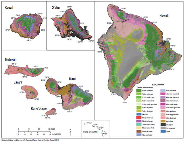
An associated report in pdf format with maps of landcover is Baseline and projected future carbon storage and carbon fluxes in ecosystems of Hawai‘i available at: https://pubs.er.usgs.gov/publication/pp1834. The figure and table below are from that document. Other maps with simpler categories of land cover are also provided in the document.

Some details for specific plots are available. A Hawaiian forest plot database has been established. A paper describing the database is here: https://www.ncbi.nlm.nih.gov/pmc/articles/PMC6172291/pdf/bdj-06-e28406.pdf. The paper states “OpenNahele includes 530 forest plots across the Hawaiian archipelago containing 43,590 individuals of 185 native and alien tree, shrub and tree fern species across six islands.”
For a discussion of the origin of the Hawaiian rainforest and its transition states in long-term primary succession by D. Mueller-Dombois and H. J. Boehmer look here: https://www.biogeosciences.net/10/5171/2013/bg-10-5171-2013.pdf.
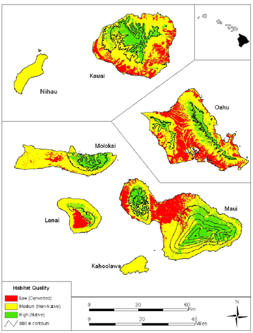
Habitat quality on the main Hawaiian Islands are shown below as depicted in the report Mapping Plant Species Ranges in the Hawaiian Islands—Developing a Methodology and Associated GIS Layers, Price et al. (2012): https://pubs.usgs.gov/of/2012/1192/. The website includes a separate file with a table of all plant species each species with a link to a map and a zip file with all the GIS files.